Highlights
Need
Increase work efficiency of contractors and speed up cable installation
Solution
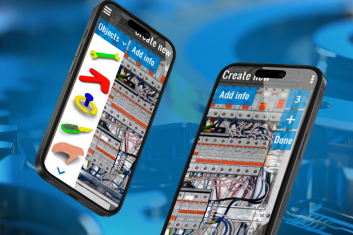
Mobile app with AR capabilities for measuring, documenting, and mapping the location of underground cables
Outcomes
48%
increase in work efficiency
1.7x
faster project completion
By partnering with HQSoftware, the customer got a mobile app with accurate satellite navigation and AR capabiltities for trench scanning.
End-users can scan the trenches, determine geolocation with high accuracy, take photos and videos, and use a map that shows the territory, topography, and other important data.
The Groundhawk solution offers the opportunity to monitor work in real-time and to simplify measurement processes and documents creation. All this results in increasing the work efficiency of contractors and faster project completion.
Looking for similar solutions or something unique to your needs?Contact us today! We’re happy to explore your needs!
Victoria Rokash
Business Development Manager

Customer
Advian is a Finnish provider of analytics solutions for the manufacturing, financial, processing, and energy industries. The company specializes in real-time analytics, location intelligence, external data, and edge computing. Using Artificial Intelligence and Machine Learning, the client helps organizations leverage data-driven decision making and improve the quality of their overall working processes.


Solution
To help the customer accomplish their objective, HQSoftware augmented their team with an Android developer and a project manager. The specialists cooperated with API developers and a product owner on the customer’s side.
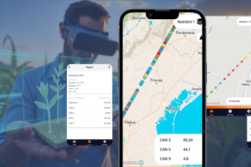
Using Augmented Reality, the mobile application scans the cable trench and sends gathered data to a customer’s server for processing. Then, via the customer’s API, the mobile application gets processed data back to create a map, which shows scanned trenches, topography, depth of installed cables, and other required information.
For better ground positioning, the solution monitors users’ geolocation. The application can use built-in navigation or a GNSS receiver, connected to a mobile phone via USB, that defines the location of a mobile phone more accurately.
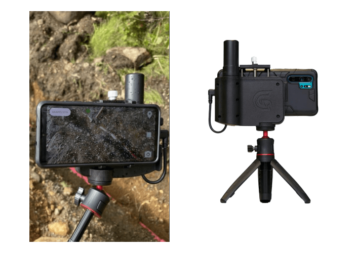
The application has two modes: trench mode and camera mode. Trench mode includes basic features, such as scanning, measuring, data sending, and so on. In addition, users can take photos and videos while they scan a path along the trench. The camera mode is used when high-quality photos or real-time videos are required.
Challenges
In the course of the project, specialists from HQSoftware had to cope with the following challenges:
- Create a user-friendly mobile application that any user can comprehend;
- Integrate Augmented Reality and navigation systems into the mobile application;
- Set up data transfer to the customer’s analytics system;
- Establish efficient data exchange with the customer’s API.
Functionality
In addition to basic features, the application includes the following:
- Capturing of Features of Interest. This function allows for measuring the distance from a mobile phone to a selected point on the surface and setting up markers during trench scanning. In addition, users can take photos of markers and write notes, such as cable descriptions or other important information. So the feature improves the working process and simplifies the process of creating documentation.
- Cable indication. At the beginning of the scanning, the application asks the user to determine the type of laid cable and its description.
- Control of contractors. After logging into the application, the user can choose and view the site where the work is taking place. If there is no site yet, the user can create a new one and indicate the underground contractors or construction specialists who work there. In this way, users structure and monitor contractors’ work.
- Site map. This is a map that shows all previously added trenches, features of interest, and cables for the selected site. The map also allows for viewing photos that were taken there previously.
Want to learn more about your opportunities? Ask us about our development services and get a free personalized proposal.
Check Out Other Works
See How We Approach Business Objectives
We are open to seeing your business needs and determining the best solution. Complete this form, and receive a free personalized proposal from your dedicated manager. Sergei Vardomatski Founder